 Heinz Leuzinger (born in 1931) completed a four-year apprenticeship as a cartographer-lithographer at swisstopo (1947–51). In the 1950s he worked for the publishers Kümmerly+Frey and Orell Füssli, producing wall and atlas maps. From 1958 to 1962 he worked as a co-worker of Eduard Imhof at the workshop in Erlenbach near Zurich, producing maps for the first edition of the Secondary School Atlas (today: Swiss World Atlas). Under the guidance of the professors Imhof and Spiess of ETH Zurich, Leuzinger contributed to many of their best maps.
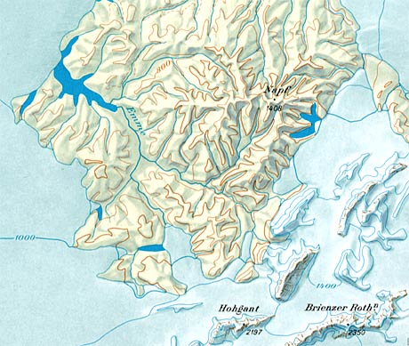
„Die Schweiz zur letzten Eiszeit“. Sheet 6 of the Atlas of Switzerland (detail) by H. Leuzinger and E. Imhof, 1970, scale 1:550,000. Available from © swisstopo.
Amongst Heinz Leuzinger’s most famous works is a map showing Switzerland at the time of the last ice age, published in 1970 as part of the Atlas of Switzerland. Leuzinger created the relief in 1966, using pencil, chalk and ink applied by brush onto a basemap at a scale of 1:200,000, with glaciologists of the ETH Zurich serving as advisors.
Leuzinger also created reliefs using an airbrush, and later on using a tablet and Photoshop.
Further resources
- Heinz Leuzinger
- Geneva relief by Heinz Leuzinger
- Venezuela relief by Heinz Leuzinger