Jean-Frédéric d’Ostervald (1773–1850), born into an influential family from Neuchâtel, Switzerland, worked as a surveyor and cartographer for many years. He produced a very accurate survey of his home canton at a scale of 1:10,000. After reducing it to 1:25,000-scale, the result was a multicoloured map comprised of 16 sheets.
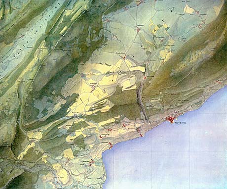
“Carte de la Principauté de Neuchâtel, levée aux frais de Sa Majesté dans les années de 1838 à 1845 par J. F. Ostervald” (Sheet No. 6) 1:25,000.
Ostervald’s superb, hand-drawn originals couldn’t be reproduced at the time of their creation because of technical limitations. He chose innovative colours close to nature: green meadows, yellow grain fields, dark green forest, brown-violet vineyards, grey-yellowish rock faces and carmine settlements.
In this map, the shading effect results from light hachures that harmonize very well with the colours of the terrain.
The description on this page is based on the article “Jean-Frédéric d’Ostervald und seine Karte des Fürstentums Neunburg von 1838 bis 1845” by Madlena Cavelti Hammer in Cartographica Helvetica 9/1994.